If you’ve heard the word photogrammetry thrown around in solar circles and nodded along without being totally sure what it means, you’re not alone. It’s a mouthful. But the concept is straightforward, and understanding it helps explain why drone-based solar design is objectively more accurate than the alternatives.
What Is Photogrammetry?
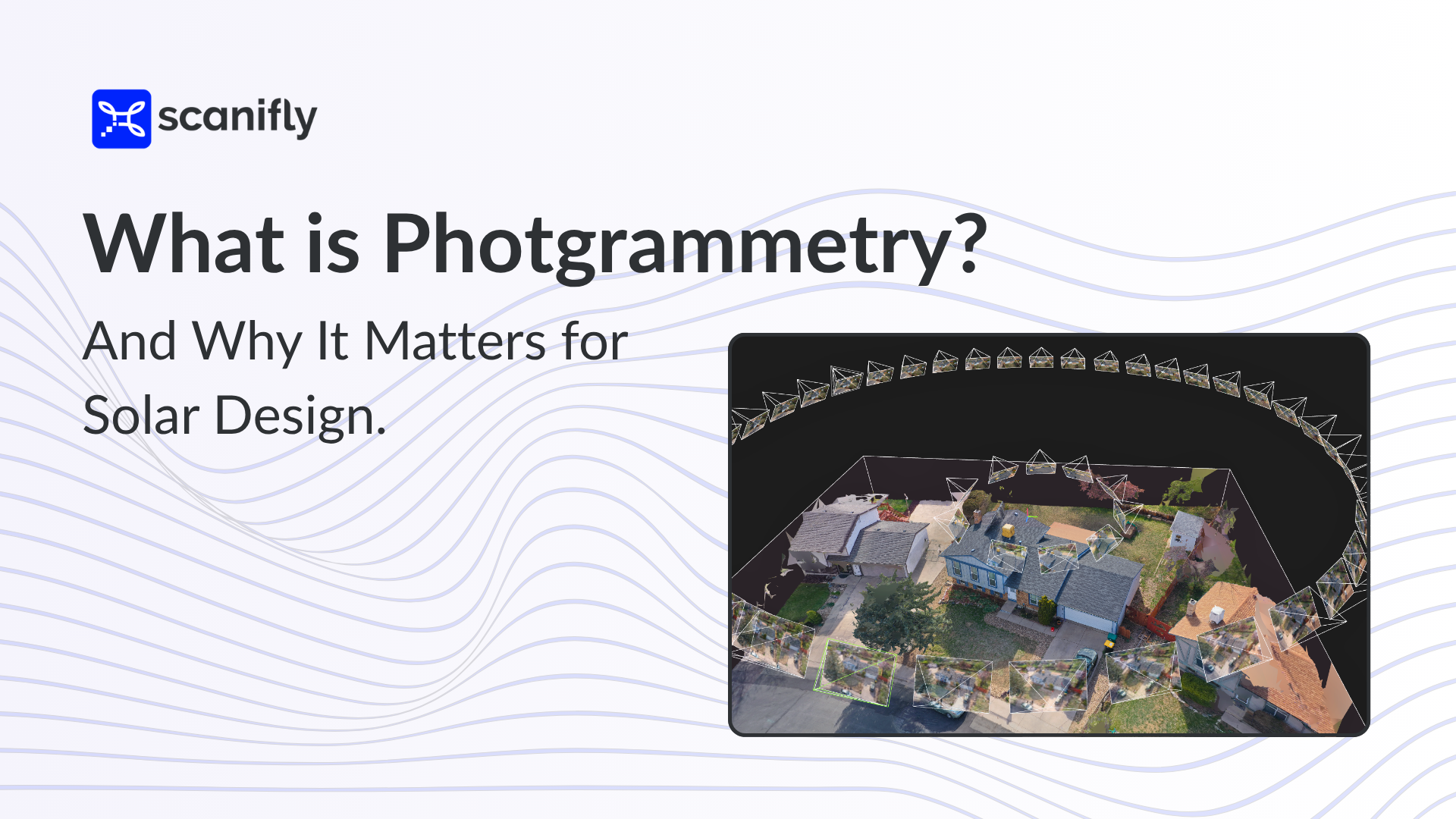
Photogrammetry is the process of taking overlapping 2D photographs and using mathematics to stitch them together into an accurate 3D model of whatever was photographed.
Your phone does a basic version of this when it uses multiple photos to measure a room. Photogrammetry takes that idea much further, using dozens or hundreds of images captured from precise angles to reconstruct a highly detailed, reliable, and dimensionally accurate 3D scene.
The way it works is more elegant than it might sound: the software identifies matching colors and key reference points across overlapping images and uses those as anchors to stitch the images together automatically. Each image also includes geotagging data — longitude, latitude, and altitude — in its metadata, so the photogrammetry engine knows exactly where to place each image and everything captured within it as it constructs the 3D model.
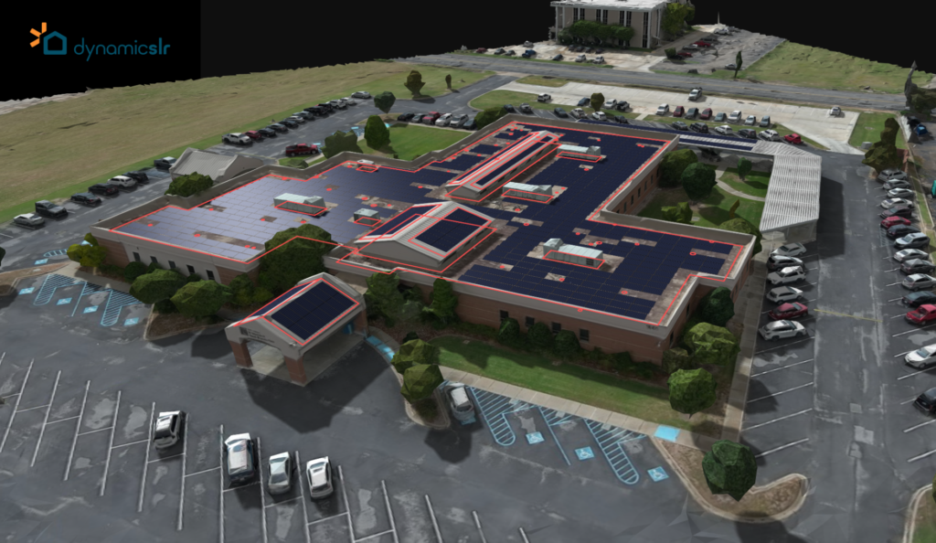
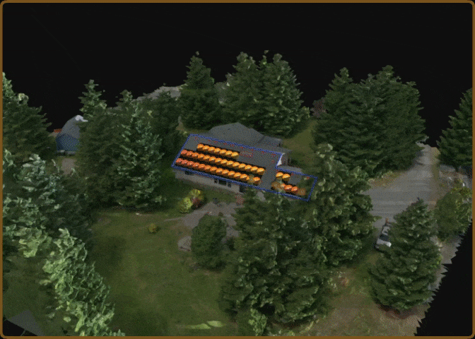
Scanifly’s software does exactly this, using photogrammetry and computer vision to process drone images into photorealistic, inch-accurate 3D models that serve as the foundation for solar design and engineering.

A Brief History of Photogrammetry
Photogrammetry has existed for well over a century, with roots in cartography, military reconnaissance, and the preservation of historical artifacts and sites. Long before digital cameras or drones, surveyors and scientists understood that overlapping photographs taken from different positions could reveal precise measurements of the physical world.
For solar design specifically, capturing images from the air matters for a critical reason: verticality. Understanding the Z-axis — the height of objects like trees, chimneys, neighboring structures, and parapet roof ridges — is essential for accurate shading analysis. A ground-level photograph tells you what something looks like, while the aerial photograph tells you how tall it is and how its shadow will move across a rooftop throughout the day. That vertical dimension is what determines whether a solar system will perform as designed.
Additionally, getting cameras airborne used to require planes or helicopters, which made the process expensive and logistically complicated. Drones changed this process entirely. A consumer drone with a camera and the ability to geotag images can now fly a programmed path over a rooftop, capturing overlapping photos from multiple angles in a matter of minutes, producing the aerial perspective that accurate solar design requires at a cost any contractor can justify.
Why Photogrammetry Matters for Solar Design
Most solar designs start with remotely sourced data, such as satellite and airplane imagery, or publicly available LiDAR. There’s no debating that these tools are convenient, but they carry two compounding problems that the industry has largely learned to accept rather than solve.
The first is data quality. Satellite images are 2D and capture no vertical information. LiDAR data, while three-dimensional, is often collected by government or municipal sources and can be five to ten years out of date in many markets. Neither captures what the roof and vegetation actually look like today, at the level of detail that a good solar design requires.
The second problem is the need for human interpretation. Because remote data is incomplete, a sales rep or PV designer has to fill in the gaps manually by estimating tree heights, guessing at roof geometry, and making judgment calls about obstructions they can’t see clearly. Two designers working from the same satellite image of the same roof can produce meaningfully different shade analyses and array layouts.
The combination of inferior data and manual interpretation is where accuracy breaks down. Both problems compound on each other on every project that relies exclusively on remote design, causing consequences that cascade from the first proposal to PTO.
This matters for three interconnected reasons:
Measurements.
Roof pitch, ridge lines, valleys, setback boundaries, and obstruction placement all need to be accurate for a design to fit on install day. Remote data approximates these, and drone-captured photogrammetry actually measures them.
Shading.
Accurate shading analysis depends on knowing the true height and position of every obstruction around a roof, including trees, chimneys, neighboring structures, and HVAC equipment. LiDAR data that’s five to ten years old doesn’t account for the tree that grew fifteen feet, but a drone flight taken on the day of the site visit captures the property’s physical reality.
Production.
Every inaccurate measurement and shade reading can impact the production estimate and mislead the homeowner. Getting it right at the design stage (ideally, the sales stage) is the only way to ensure the system delivers on its promise.
The Benefits of Photogrammetry and Scanifly
A drone flight during the first homeowner visit or site survey gives you current, site-specific 3D data. Scanifly turns that data into a photorealistic, inch-accurate 3D model, providing the canvas for designing and engineering a precise solar system rather than an approximation built from outdated remote imagery.
That accuracy cascades through everything downstream:
More accurate shading analysis.
Trees, chimneys, vent pipes, and neighboring structures are captured as they actually exist on the day of the site visit, not approximated from outdated aerial data. Shading analysis based on accurate 3D geometry yields production estimates that hold up in the real world.
Precise panel placement.
Roof pitch, ridge lines, valleys, and obstructions are measured accurately, so the design submitted for permitting reflects what can actually be installed. Fewer surprises during installation means fewer costly redesigns and in-field change orders.

Honest production estimates.
When the model is based on real-time onsite data, the production estimate will be accurate. That’s better for the homeowner, better for the installer’s reputation, and better for TPO companies underwriting the project.
Faster, safer site surveys.
The traditional site survey involves someone climbing onto the roof with a measuring tape, pen and paper, and a Solmetric SunEye. It’s time-consuming, physically risky, and highly dependent on the individual doing it. A drone-based survey standardizes the process. The drone flies automatically, in two concentric circles above the home, and the photogrammetry software processes the images the same way every time. The output is consistent and accurate. Fewer people on roofs also means fewer falls, which remain one of the most common causes of serious injury in the solar industry.
The Bottom Line for Photogrammetry in Solar Design
Photogrammetry is a mouthful, and the technology can seem almost magical when you see a photorealistic 3D model of a property materialize from a seven-minute drone flight. But the underlying process is remarkably simple. Fly the drone. Upload the images. The software identifies matching reference points across overlapping photos, uses the geotagging data to place everything in three-dimensional space, and reconstructs the scene with inch-level accuracy.
The result is perfect measurements, an accurate shade scene, and a production estimate the homeowner can trust. Everything else in the solar design process gets easier when that foundation is right.
Frequently Asked Questions
What is photogrammetry in simple terms?
Photogrammetry is the process of turning overlapping 2D photographs into accurate 3D models. The Scanifly software identifies matching colors and key reference points across images and uses GPS data in each photo to reconstruct the photographed scene with precise measurements.
How is drone photogrammetry used in solar design?
A drone flies over a rooftop, capturing overlapping images from multiple angles. Those images are processed into a 3D model that accurately represents the roof’s geometry, obstructions, and surrounding environment. That model then serves as the trustworthy foundation for panel placement, shading analysis, and production modeling instead of needing to rely on outdated, pixelated remote imagery.
Is drone photogrammetry more accurate than LiDAR for solar design?
For site-specific measurements and shading accuracy, yes. Drone-based photogrammetry captures current, on-site conditions at high resolution on the day of the site visit. Publicly available LiDAR data is often several years old and lower in point density, which can produce less accurate shading models in areas where trees, structures, or other obstructions have changed.
How long does a drone site survey take?
Most residential rooftop surveys take roughly 10 minutes of flight time. Processing the images into a 3D model typically takes additional time (roughly 30-45 minutes) depending on the software and computing setup, but the overall process is significantly faster than a traditional manual site survey and design process.