Key takeaway: LiDAR is a government-funded data source that shows geospatial 3D information, such as structure mapping, vegetation, and terrain, making it helpful for collecting rough measurements and shade data for solar surveys. However, it’s not a completely accurate source and it’s not always available. This makes LiDAR a great fit for a platform like Scanifly Prelim on top of other data sources, like satellite or drone-based imagery.
Solar Surveyors need to know a lot about a property to contribute to sales, engineering documentation and install planning. Of the multiple data sources you could use in solar, LiDAR is perhaps the most opaque and difficult to understand.
For instance, we know LiDAR data is a compilation of topographical data. We also know that the US government collects this information for its own purposes. But that raises many questions: How did this happen? Where is it stored? What is the data good for? How is it used in solar?
There are so many questions, but very few answers.
What is LiDAR data and where does it come from?
LiDAR, which stands for Light Detection and Ranging, is a remote sensing technology that uses laser light to measure distances and create detailed, three-dimensional maps of the environment. In the context of solar software, LiDAR data that is acquired using a 3D scanner mounted to a manned aircraft is commonly used.
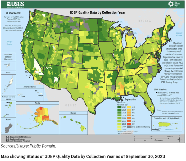
The acquisition of this data in the United States was government-funded through the United States Geological Survey (USGS) 3D Evaluation Program. However, anyone with a sensor and a drone can collect LiDAR data; if you collect it yourself, you can even apply to have it added to the USGS database.
Who captures LiDAR data and why do they do it?
Anyone can collect LiDAR data. That said, large-scale data collection is often funded by governments, particularly the USGS, that want to better understand the topographical makeup of a given area. From there, the data is made publicly available both through government websites and third-party providers. Some examples of LiDAR data sources are the United States government and the Canadian government.
Since anyone can collect LiDAR data, there are also numerous private databases such as the National Ecological Observatory Network (NEON) and OpenTopograhy.
What’s the science behind LiDAR data and how is it collected?
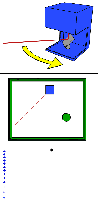
LiDAR is collected using high-tech sensors mounted onto airplanes, helicopters, drones, or ground-based scanners such as tripods or vehicle-mounting. In LiDAR systems, a laser scanner combined with navigation sensors, emits laser pulses towards the target area, and measures the time it takes for the laser pulses to return after hitting objects in the environment.
By calculating the travel time of the light pulses, the LiDAR system can precisely determine the distance to each point on the surface of objects, creating a depth and reflectivity map. These distance measurements are then used to create a point cloud, which represents the terrain, buildings, vegetation, and other features.
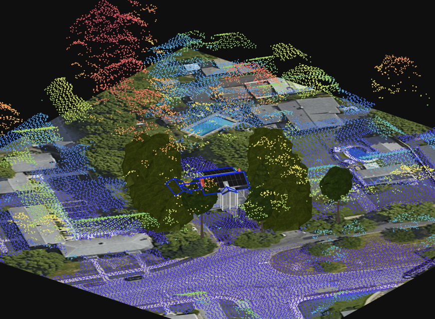
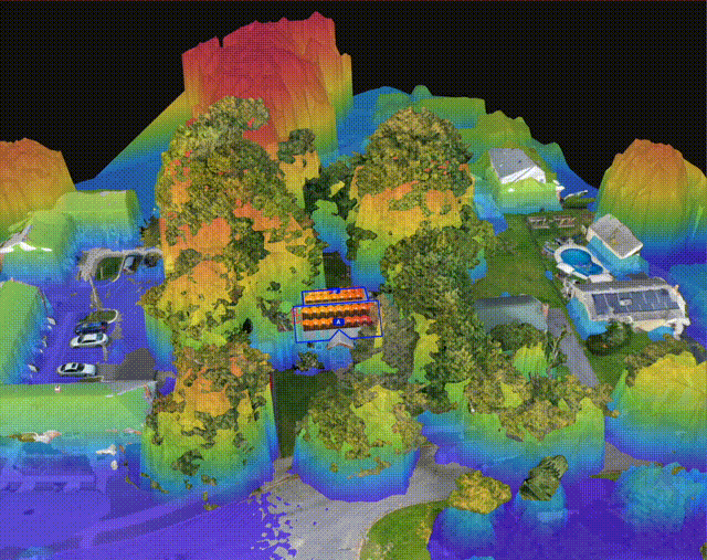
LiDAR point cloud in Scanifly Prelim
Who manages existing LiDAR data and plans for future data collection?
LiDAR data management depends on who collects it and why.
For example, governments might manage their own data sources and selectively choose to collect more data themselves or leverage trusted third parties.
Private companies or individuals, on the other hand, can also manage their own data collection processes. For example, FlyGuys (a Scanifly partner) offers LiDAR collection services for various use cases.
Because LiDAR collection varies and is controlled by different parties for different reasons, it can make update timelines challenging to track or predict, even if the schedule appears consistent at first. For instance, the US government regularly funds the collection of LiDAR data to update its maps. However, that doesn’t mean all data is only ever six months old; updates may only apply to specific regions, with some data being more than five years old.
When new databases are available, the USGS publishes a press release on its website.
What can you do with LiDAR data in a rooftop solar context?
LiDAR data helps Solar Surveyors and Designers maximize and optimize panel placement. It’s one data source of many, but provides rough heights and pitches for both the roof as well as potential obstructions like trees or outbuildings.
With this level of insight layered with other data sources, Designers can identify the best roof planes for panels, taking into account things like shading, sunlight exposure, and obstructions.
How does remote LiDAR differ from on-site drone LiDAR?
The key difference is data recency.
All LiDAR data is the same, regardless of whether you collect it remotely (via airplanes, for instance) or on-site (via a LiDAR sensor on a drone). However, since you cannot be certain about updated timelines with remote data, the only way to ensure you have up-to-date information is with a drone on-site.
LiDAR is great for preliminary designs because the data is free and can be accessed quickly.
When it comes to confirming measurements with complete certainty, on-site measurements using other tools (like drone cameras to create a photorealistic 3D model) become crucial.
LiDAR data overlayed an on-site drone-based 3D model
What are the limitations of LiDAR data in solar?
When considering whether to use LiDAR technology, you should pay attention to a few limitations:
-
Spatial resolution: LiDAR data that is acquired using manned aircraft flying at a high altitude will have a lower spatial resolution (point density per square foot). LiDAR data acquired using a drone flying at a lower altitude will have a higher spatial resolution (point density per square foot). Keep in mind there are other factors at play here that determine spatial resolution, such as aircraft speed and the number of channels (lasers) in the LiDAR sensor.
-
Sparse detail: LiDAR shows only the general outline of roofs and other items on a site in heatmap-style Satellite imagery will offer some additional detail, but only on-site imagery will clearly show all details.
-
“Noisy” data: If atmospheric conditions aren’t ideal, you may end up with additional data points on your map that are actually obstructions (for instance, a tree branch moving in the wind or, in severe storms, objects lifted off the ground).
-
Challenges with trees: LiDAR sensors cannot “see through” dense tree canopies, affecting data sets in rural or suburban areas with trees that might otherwise be an excellent fit for solar.
-
Color sensitivity: LiDAR lasers have difficulty picking up glossy black objects or dark-tone materials with light-absorbing properties.
-
Data recency: LiDAR is not always up to date, with some regions not having been updated since 2017 or prior. For this reason alone, you need to confirm with other data sources.
-
Cost: While the data is made freely available, some third-party providers package it or conduct analysis that makes it easier to use in solar; these offerings typically come at a high cost.
LiDAR: A great preliminary dataset for solar
Sometimes, a quick preliminary design is all that’s needed to help a customer understand what solar can do for them. In times like these, LiDAR data is a great way to get rough measurements. But at the end of the day, it’s just another remote geospatial reference.
When it comes to the entire project lifecycle, you need both remote (like LiDAR) and on-site data to confirm measurements. Accurate measurements are especially crucial if you offer production guarantees.
Once you have accurate data, you’ll want a single platform to combine all data sources for maximum reliability, accuracy, and ease of internal planning—we built Scanifly’s One Design Platform for this exact purpose.