We know that 76% of surveyors admit to taking shortcuts during the survey process. One of the more common shortcuts is leveraging satellite imagery to avoid going onsite altogether. But unfortunately, relying on satellite imagery creates a host of other problems for designers. While satellite imagery is great for preliminary designs—particularly for a quick-turnaround sales conversation—it has four distinct problems that make it dangerous to use as the sole resource for array design.
1. Blurry or pixelated satellite images lead to inaccuracies
We’ve all seen blurry satellite pictures on Google Earth. Unfortunately, this is more or less what many solar contractors have to rely on—even third-party satellite image providers can’t provide much higher quality. You can make out the general shape, which is why they work for quick sales-focused prelim designs.
But when it comes to full designs, blurriness causes problems:
-
Blurry or pixelated images of roofs require designers to take a best guess rather than use real measurements.
-
Satellite imagery isn’t clear enough to spot roof blemishes, clearly mark obstructions, or note any obvious exterior roof health issues, meaning designers have to either avoid those spots entirely (creating an artificially small system) or risk roof damage that installers will have to manage around (which could lead to call-offs).
In short, the graininess of satellite imagery means you miss little details that could have significant design implications.
2. Satellite imagery fails for new home context
There is a lot of new construction around the world and many new homeowners want solar from day one. On the flip side, an increase in natural disasters means properties no longer look like they once did. But you can’t use satellite imagery for this because it doesn’t exist—satellites can take years to update, so you might only see a pit in the ground or a different house.
Even if the image is updated to show the house, you run the risk of it being wildly out of date and missing:
-
Any additions or outbuildings (like garages).
-
Fully grown trees that might cause shade.
-
Community infrastructure, like electric poles and wires, that might cause obstruction.
If you are a solar contractor working with new-build homes or working in areas with high rates of natural disasters, satellite imagery won’t help you.
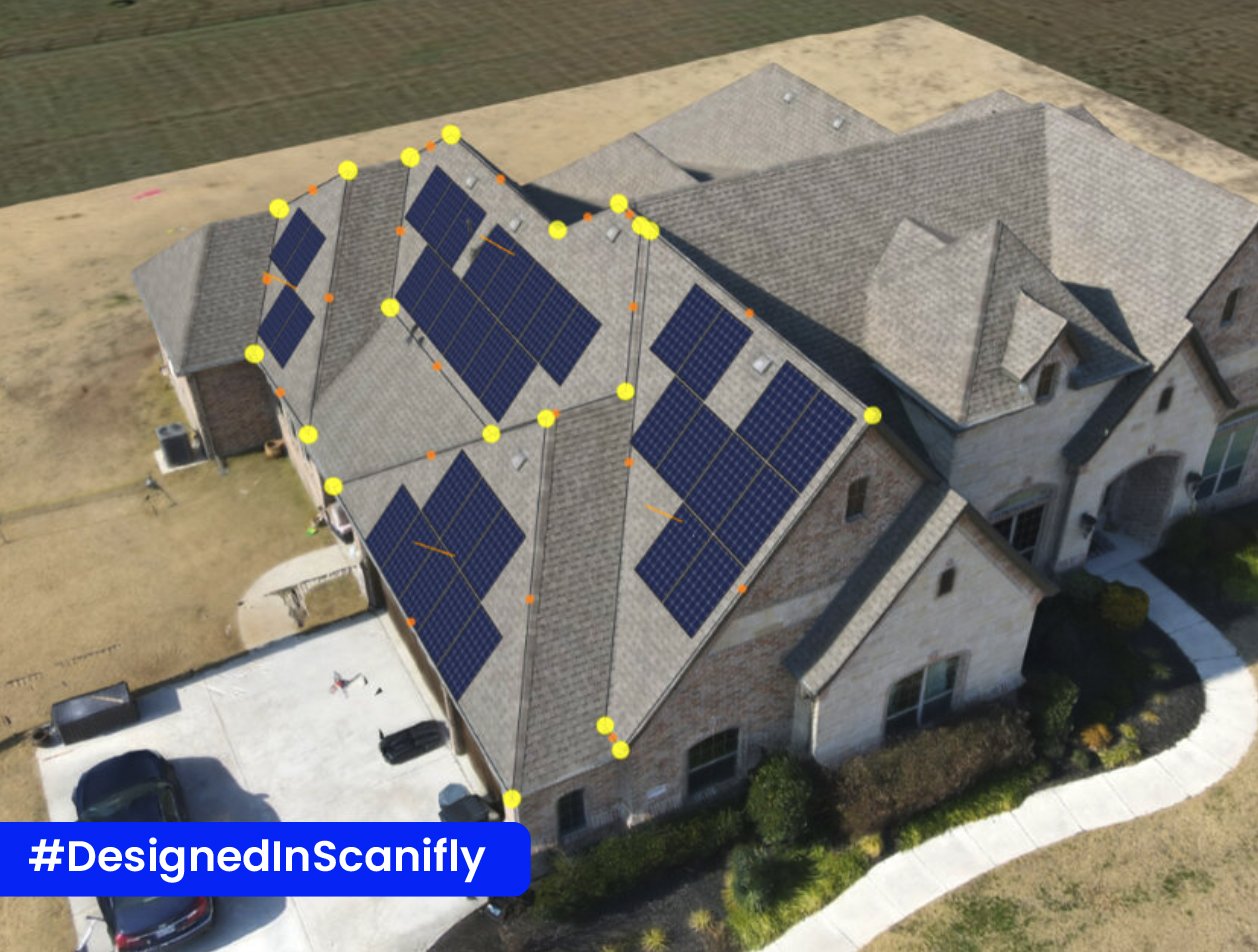
3. Satellite imagery misses roof heights, angles, and curves
The top-down nature of satellite images makes it impossible to accurately measure roof hips, curves, valleys, and edges.
When a designer can’t see these elevations clearly, they have to estimate based on what they can identify. However, sometimes elevations are so pixelated that a designer cannot tell if something is going on, which could lead to an improper design that needs multiple redesigns to get right.
It’s also tough to see precisely where the roof lines start and stop. This produces another challenge with keep-out spaces on the roof to adhere to either homeowner requests or jurisdiction regulations.
4. Satellite imagery misses shading issues
Not taking shading into account often results in a system that can’t perform as promised, creating negative word-of-mouth advertising for you as a contractor and potentially putting you at financial risk if you offer production guarantees.
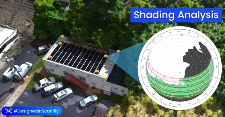
In particular, satellite imagery is prone to miss:
-
Vegetation and tree growth because satellite imagery is almost always out of date.
-
Power lines and other community infrastructure that’s updated frequently over the years.
-
New construction around your home that might cast additional shade.
Keep satellite imagery preliminary
While it’s a bit grainy, satellite imagery has enough quality to support a quick preliminary design. This has incredible value for sales teams and can help inform the designer on what kind of system to build, if possible. However, the simple reality is satellite imagery is not high-quality enough to design from.
It’s critical to clarify all preliminary designs from satellite imagery with an on-site survey. This is important to both set customer expectations ahead of installation and to ensure every piece of the solar puzzle—from survey to design, permitting, and installation—is based on completely accurate data.