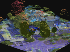
LiDAR
What Is LiDAR And Why Should You Care?
Key takeaway: LiDAR is a government-funded data source that shows geospatial 3D information, such as structure mapping, vegetation, and terrain, making it helpful for collecting

What Is LiDAR And Why Should You Care?
Key takeaway: LiDAR is a government-funded data source that shows geospatial 3D information, such as structure mapping, vegetation, and terrain, making it helpful for collecting
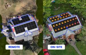
3 Reasons You Need Both Remote + On-Site Data For Installing Solar
Key takeaway: Combining remote and on-site data ensures accurate system sizing, production estimates, and hardware costs. Making a preliminary design is beneficial for sales conversations,

3 Reasons You Need Remote + On-Site Data For Install Planning
Sales proposals almost always leverage satellite or remote imagery, but there’s a problem. Solar surveyors and designers overwhelmingly report satellite imagery is not fully accurate and needs to be verified onsite. Find out three distinct reasons that impact not just the ability to complete the project, but also profit margins.