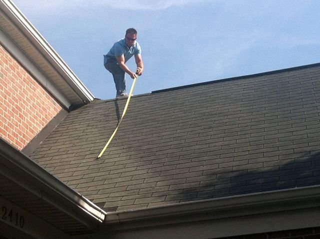
If your manually-measured surveys are “always accurate,” it’s likely that one of a few things is happening:
- Your surveys take a very long time and are costly in terms of salary hours for two Surveyors per job
- You only measure the proposed roof planes and might miss better areas for solar or overflow space in case of a change order.
- You’re using conservative measurements like overly-large setbacks to accommodate for errors or not capturing every obstruction and roof detail.
- You’re using remote imagery, which means your Designers are working overtime to correct mistakes or your Installers are fixing issues on install day
- Your installers aren’t telling you what actually happens on install day and have accepted a revision as just “part of the job”.
In all cases, your process is not as efficient as it could be and you’re delivering a suboptimal output for customers—for instance, installing artificially small systems to compensate for setbacks. What’s more is your stellar Surveyor becomes a central person risk if they are sick, go on vacation, or quit after being physically worn down by the job. Perhaps your Design and Installation teams are wasting a lot of time fixing measurement errors that didn’t need to be there in the first place.
The solution is to look at new technologies, like drones and mobile apps, that can deliver equal accuracy and consistent outputs regardless of the surveyors across all projects.
The Little Ways To Derail A Manual Survey
Manual surveying is, at its best, unsustainable long-term. At its worst, it physically wears out your surveying team and wastes time throughout the project.
Issue 1: You’re burning out your people and creating key person risk
Only doing manual surveys limits who can be a Surveyor. And even those folks won’t stick around for too long if they get burnt out or injured.
One Contractor faced this issue head-on when a Surveyor tore his ACL during a recreational soccer game. This occurred out of work – life happens! But as a smaller shop, he was the only Surveyor in the region — suddenly, every project got delayed by weeks. Had the Contractor used drones, the Surveyor could have safely continued his work from the ground.
Even without these big risks, there are little issues that compound. For example, sweat on the page can make it impossible to read. Depending on who is writing, a “4” can look a lot like a “9”. Training new surveyors on your exact methodology is time consuming. And even if that’s not happening, the handoff from manual paperwork to digital design platforms is time-consuming and error prone.
Issue 2: “Accurate” based on shortcuts still causes problems
Being conservative with measurements (like large setbacks) to overcome the ineffectiveness of satellite imagery results in a suboptimal system for homeowners, lowering your overall ability to grow through word-of-mouth from happy customers.
Saying not everyone needs a max fill is fair, but only for a subset of the market. Not measuring all roof planes means you miss opportunities if a homeowner wants to make a change for aesthetic or lifestyle reasons (e.g. expanding the system to the garage because they want to buy an EV).
Conservative measurements could also mean money left on the table for contractors and mispricing a system for a prospect. This could lead to missed revenue or, even worse, a lost deal to competition.
You won’t get full property context unless you take hundreds of pictures, which is almost impossible to stitch together manually. Even if you could, you still won’t have full visibility unless you take it from the air using a drone.
Issue 3: You’re relying on an inefficient, unscalable, unsustainable process
Doing things manually already has key person risk.
But more than that, it’s resource inefficient:
- More than 75% of Surveyors do four or fewer manual surveys per day due to time constraints. One third (35%) do just 1-2 per day. Manual work is not only a capacity-limiting factor, but quality is likely to suffer as the day goes on.
- You have to send two people to survey safely (three for a commercial roof), whereas with a drone you only need one.
- Many homeowners don’t want people harnessing into their roof, causing damage just for a survey.
- Not capturing all roof planes or missing measurements on a single, steep roof plane could result in revisions, which have hard costs (on average $750) and can result in delays due to team scheduling and repermitting.
“Plan sets used to take 3 weeks. Now we go from survey to a stamped plan set in 3 days with zero revisions [using Scanifly],” said Ethan Goddard, Vice President of Energy Technology at Solar Energy Services.
Keep Your Accuracy, Improve Everything Else
At the end of the day, manual surveys gain “full accuracy” through compensatory methods — you’re giving up quality or comprehensiveness.
By taking shortcuts, you’re missing a huge opportunity to sell the best array for the person paying for it (the homeowner). This means lost revenue, lost customer experience, and lost growth opportunities.
Or… you can keep all these opportunities alive by using the right technology.
Drones are equally or more accurate to manual surveying but take far less time, and they provide a better customer experience because you can stand behind the accuracy without compensatory tactics. It’s also safer for your team and you won’t have the same fitment issues to handle on install day (we’ve done these tests ourselves and many Contractors have publicly stated their own results, like Dynamic Solar and Namaste Solar)
“[Using only remote designs] some homeowners will decide to cancel because they are unsure what it’s going to look like in the end,” said Jan Bautista, a Site Survey Coordinator at Dynamic Solar. “Being able to show a photorealistic 3D model [in Scanifly] is really helpful here.”
Further, technology is more scalable and sustainable. Drones are easy to learn (it takes about 1-2 hours per day for 2-3 weeks, then you’re done). While there is the option to outsource to a third-party drone pilot, our recommendation is to give your in-house Surveyors the technology. This also allows you to hire former Installers, Technicians, and other experienced people as Surveyors, so you have more choice for the role.
Build A Sustainable Business For The Future

Even if your manual methods are accurate today, it’s worth trying out new technology if it can significantly improve your capacity, efficiency, and margins.
We recommend trying a drone then verifying manually with your own house, office, or an already completed project — that way you can get initial results immediately for comparison. Alternatively, consider hiring a third-party drone pilot to get initial results quickly. If you want, in some cases, Scanifly will even come and do an on-site demo with you so you can compare the results yourself.