Almost all (98%) of Contractors will conduct an on-site survey prior to installation; more than half will do a survey prior to closing the sale, underscoring the importance of high-quality data.
Depending on who you talk to, data collection methods differ—some Surveyors use drones while others measure using remote data sources or by hand. Further, nearly two-thirds (62.2%) use a mobile phone or app to collect internal data.
But it’s not just collecting data you need to worry about.
Almost all (98%) of Contractors will conduct an on-site survey before installation; more than half will do a survey prior to closing the sale, underscoring the importance of high-quality data.
Data collection methods differ depending on who you talk to—some Surveyors use drones, while others measure using remote data sources or by hand. Further, nearly two-thirds (62.2%) use a mobile phone or app to collect internal data.
But it’s not just collecting data you need to worry about.
First, you need accurate data—for instance, 81% of Surveyors said that on-site data is better than remote data. Second, you need that data uploaded quickly so relevant teams (Sales Reps, Designers, and Project Managers) can begin to act on it.
The solution is to upload onsite data in real time using technology (e.g. drones and mobile apps). This can occur (1) automatically because your mobile app syncs with your data repository via the cloud or (2) manually on-site or during drive times.
Uploading data from the field will not only save Surveyors time but also improve project efficiency as Designers and Engineers can begin their work earlier and with more confidence. The key is to make sure you’re using a centralized, data-agnostic platform; this ensures accurate uploads the first time, so you don’t have to deal with revisions or change orders down the line. And since the majority of Designers say that they have to revise 25-50% of projects, these time-wasting delays can thwart an entire project operation.
Getting ready for data uploads
Before you can upload pictures and videos from the field, you need to ensure you’ve got two things in place.
1. A good internet connection: This can be on WiFi (if your vehicle is equipped), a good mobile network for your phone, or tethering your phone to your computer.
2. An SD card and reader: Many devices, including drones have their own memory cards, so this shouldn’t be an issue. For example, Scanifly contractors can use an SD to transfer drone images to your phone or computer. This allows them to also be drone agnostic and avoid issues like DJI discontinuing SDK support on iOS.
How to upload data from the field
Uploading from the field is a simple three-step process. You can either do this on the client site or drive to a nearby parking lot; this whole process should only take 5-10 minutes.
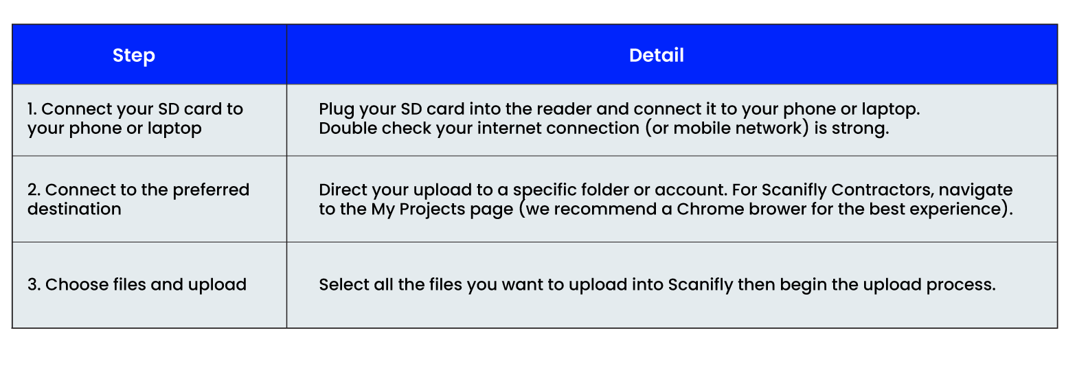
After you start the upload, you can drive to your next site—the upload will happen automatically in the background.
Uploading tips and troubleshooting
We recommend avoiding certain images: with sun glare or whiteout, taken from far away, blurry pictures, ground images, or those with drastic color differences.
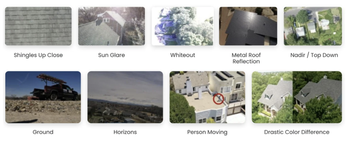
Image types to avoid uploading
If uploading gets stuck, there are some easy troubleshooting steps. First, check that you’ve got the latest software on your device, that you’re using the latest version of Scanifly’s app, and that you have a strong enough internet or mobile connection. From there, close all non-essential apps to free up RAM space on your device to run the upload. If it’s still stuck, make sure you have enough storage on your device for the files to transfer from the SD card, either deleting files or clearing caches to free up space.
Who benefits from accurate data uploaded quickly?
Every person in the solar project process benefits from high-quality data, uploaded quickly:
Sales Reps can have more productive conversations and close deals faster because they’ll have accurate information about the site.
Surveyors gain more capacity in their day by maximizing drive times rather than end-of-day uploading.
Designers can start working on either preliminary designs or engineering documents quickly, speeding up the design process and reducing or eliminating revisions—this can sometimes unlock a 1-3 day time savings, and get permits filed much faster.
Survey Managers or anyone else verifying data will be able to catch missed field information critical to the project almost immediately, preventing a second truck roll, or worse, a permit refiling or expensive change order (e.g. MSP upgrade).
Operations Leaders have more capacity on their team across the board because quick uploads means maximum team utilization. This makes the entire work process smoother and easier to account for sick days, vacations, or other slowdowns outside of their control.
Installers can feel more confident they won’t have install-day cancellations or change orders because they have the verified site context and project information.
Finance and admin teams are able to file for milestone payments with their financial providers or collect customer deposits faster throughout the project development process.
Customers get accurate data they can trust, resulting in the installed system matching what they were promised.
Optimize your survey process to improve the whole workflow
Uploading data from the field may seem like a benefit solely for Surveyors or Sales Reps who conduct site assessments, but it actually creates significant downstream efficiencies. Not only does a Surveyor save time, but uploading accurate data from the field also ensures the fewest mistakes, reducing or eliminating change orders, and driving some of the best word of mouth referral programs.
In the end, using the right technology—drones with mobile uploading from the field—means an accurate design that delivers incredible benefits for both internal teams and customers.